

Overview
2023 NOTICE: HABITAT RESTORATION UNDERWAY
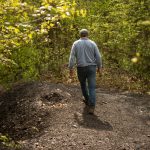
Allegheny Land Trust (ALT) is working on habitat restoration efforts at Bethel Green by combatting invasive species and increasing diversity to foster a healthier ecosystem. Work began in January 2023 and active work is expected to continue through fall 2023; here is a flyer with more details.
As we mend the impacted trails and cleared areas, we ask visitors to stay on the existing trail system. To take part in forest restoration volunteer workdays, visit our event calendar for public workdays with ALT and the Isaac Walton League. Thank you for your patience and support!
—
ALT worked with in cooperation with the municipality of Bethel Park, the local community, and other civic-minded partners to acquire and permanently conserve one of the largest remaining green spaces in the Bethel Park for the health, well-being, and enjoyment of current and future generations of area residents.
The 40.5-acre Bethel Greenway Project is located within the municipality of Bethel Park near the intersections of Route 88 and Connor Road and Valley Drive along the municipality’s northwest border with Castle Shannon Borough.
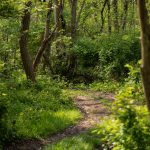
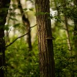
The green space is within walking distance of several thousand neighbors, and features an informal, well-kept network of crisscrossed hiking trails, relics of the area’s industrial history, and a variety of resilient species of flora and fauna that have begun reclaiming the space.
Background
The Bethel Green Conservation Area was permanently protected at the end of March 2020 following an impassioned grassroots campaign. Often, it takes months to develop both an understanding of and passion for the value of protecting green space. In Bethel Park, the community immediately understood the value of this green gem, and very quickly took it upon themselves to do the grassroots awareness and fundraising work. Thanks in part to their hard work, this land is now forever protected for current and future generations.
The land itself is a relic of the area’s industrial history as it was part of the Mollenaur Mine #3 complex and was used from the late 1800s through 1939 and a dumping ground for dirt and rock tailings from the mine.
The once large and unsightly mountain of debris has evolved over time into an excellent demonstration of nature’s ability to recover if given the opportunity. The once imposing tailings pile has been almost completely reclaimed by nature, and is now mostly forested by black cherry, sumac, and birch trees.
Additionally, this property is at the headwaters of the flood prone Saw Mill Run, and thus serves an important role in sequestering and filtering 3.2 million gallons of rain water per year.
Its protection preserves natural scenic beauty, provides a place for close-to-home outdoor recreation, fosters environmental and historic education opportunities, prevents further congestion on area roadways, mitigates flooding, and enhances the attractiveness of the municipality to younger homeowners who increasingly cite “proximity to open space” as a significant factor in their selection of a community to call home.